|
John B. Egger
|
|
|
John B. Egger
|
|
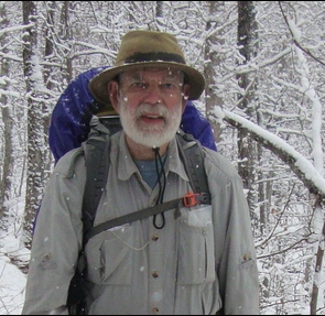
I wrapped up a 40-year academic career, the last 25 years of it as a professor of economics at Towson University, with my retirement in June 2012. I’m now more interested in my hobby since childhood, amateur (“ham”) radio (for that, see my page on the qrz.com ham-radio website, https://www.qrz.com/db/K3GHH), reading, playing the piano (mostly Jelly Roll Morton and rags)… and the activities depicted here.
|
|
|
|
|
Hiking the Haute Route west, from Zermatt Switzerland toward Chamonix France, I reached Forcletta Pass at 12:20 PM on July 6, 2012; elevation 2874m. I rolled into Zinal at 4:45. I ran out of time at Arolla, well short of Chamonix. |
|
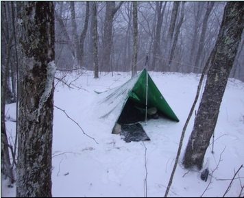
I crawled out to find this, on the morning of March 25, 2013. It was one of several ~13°F nights during my 6 weeks on the Appalachian Trail. This campsite was on a windswept ridge just north of Cold Spring Shelter in North Carolina. |
|
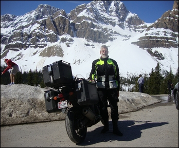
May 27, 2017: My Honda NC-700X, on the way from Towson MD to Anchorage AK (5,162 miles), at Crowfoot Glacier on Alberta’s famous Icefields Parkway (Rt. 93). I’d camped just north of Lake Louise, at British Columbia’s Yoho Provincial Park, the previous night and reached Dawson Creek, Milepost Zero of the Alaska Highway, the following day. |
Alaska by Motorcycle
|
2017: In the summer of 1965 I set out from Pennsylvania for Alaska on my 1964 Honda Super Hawk... and prudently backed out at Lake Louise AB with little money and an ill-running bike. With somewhat more satisfactory finances and 50 years of improvement in motorcycles, I left Towson on May 18 2017 with 4,285 miles on the 2014 Honda NC-700X odometer; when I reached Anchorage on June 2 it read 9,447. This is the northbound photo album and daily NOBO journal, and here are the southbound return trip photos and the SOBO journal (June 27 to July 10, odometer 9,698 to 14,889 miles). The Lake Louise campground, my 1965 turnback point, wasn’t open yet, but it was a huge thrill to duplicate some of the Super Hawk’s trip and to carry its plan to completion. The camping was easy compared to backpacking; with no concerns about weight, I enjoyed the luxury of the spacious Eureka Mountain Pass 2 tent. Except for an Australian rider’s rented Suzuki V-Strom 650, mine was by far the smallest-displacement motorcycle (671 cc) I met on the trip. The bike received a new chain in Anchorage and a new tire in Fargo ND, on the way home. |
|
2018: In early May I bought a new 2018 Honda Gold Wing, and left for Alaska May 18 with 340 miles on the odometer. After a southwestern swing to Mesa Verde in Colorado we headed north through Utah, Idaho, and Montana to Jasper AB and west to the Cassiar Highway, the Alaska Highway, and Anchorage. Here’s the northbound photo album, and here’s the NOBO daily journal. Returning home a few weeks later, we obtained new tires in Edmonton and entered the United States via Michigan’s Upper Peninsula and the famous metal-grill Mackinac Bridge. Here’s the southbound album, and here’s the SOBO journal. The round-trip put 10,146 miles on the beautiful Wing. |
|
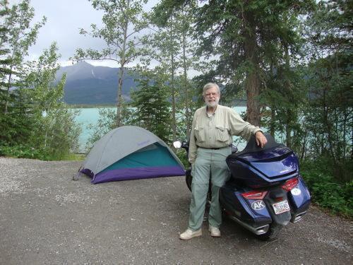
2019: For my third ride, I chose a new experience: the Alaska Marine Highway ferry from Bellingham WA to Haines AK. With chancy weather (tornadoes and storms in south-central US) and a rigid May 31 reservation on the ferry I allowed a few extra days, but we escaped the bad storms and enjoyed those extra days camped in Mt. Baker-Snoqualmie National Forest near Bellingham. The 2½ day cruise was enjoyable except that neither I nor the car-deck workers secured the Wing properly and it fell over when we hit ocean swells. The only serious damage was to the automatic-transmission control plate, a small plastic panel that popped off and cracked. I cautiously snapped it back into place, and it worked, but caused anxiety all the way to Anchorage and then back to Baltimore. We disembarked at Haines, made the three-hour ride north to Haines Junction YT, then two days to Tok and Anchorage: We were “home”! (Northbound journal with photos is here.) After a new tire we headed for our real home on June 26, sticking to the Alaska Highway all the way to Dawson Creek (home of the Milepost Zero). We rode east to Grande Prairie AB, south on the Icefields Parkway at Jasper (in light rain and fog… but I’ve seen the gorgeous views several times) to Banff, then east on the Trans-Canada to Calgary and beyond. Following the wonderful Lake Superior Circle Tour, we entered the United States at Sault St. Marie, Michigan and rode the (in)famous metal-grid Mackinac Bridge. After a day’s delay in Milan, MI for a new battery, we reached my brother Bob’s in Pennsylvania on July 11 and arrived home on July 12. (Southbound journal, photos here.) The ferry saved about 1,000 miles, but the round-trip ride added 9,500 to the Gold Wing’s odometer. |
Southeast by Motorcycle
|
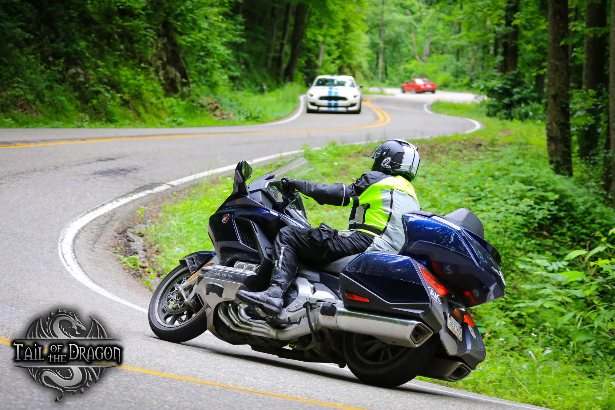
May 2022: In late May 2022, the Gold Wing and I headed south. We rode the entire 469-mile Blue Ridge Parkway, then did the famous 11-mile ride (near its southern terminus) “The Tail of the Dragon.” (The photo at the left is one of two professional photos I purchased. The sports cars were two of hundreds of cars and motorcycles playing on The Tail that sunny Saturday morning.) Moving down to Florida, we enjoyed several days’ visit with our --- well, I guess just my --- niece in St. Petersburg, then picked up the fourth and final specific goal of this tour, Key West FL. We made it back to Florida City on the mainland just before a significant tropical storm began on June 2, and remained holed up in the motel there until Sunday June 5 when we got back to St. Pete’s. On the return home, I noticed that the west edge of South Carolina came very near to the route I’d planned up through Georgia to Tennessee, so a half-hour jag east picked up SC for my “states visited” map. We arrived home, as planned, on Friday June 10 2022. The photographic record of this trip, such as it is (lots of fog on the BRP), is here. Captions appear when the cursor is hovered over the photo.
|
Appalachian Trail
On March 11, 2013 I began my northward trek on the Appalachian Trail by leaving the Springer Mountain GA summit at 3:30 PM, twelve hours after crawling out of my bed at home. Six weeks later, in Erwin TN (342 miles) on April 22, I decided I’d had enough. A fellow hiker, driving south through Asheville NC, dropped me at the airport, and I was home that evening. This photo album records my time on the Appalachian Trail. The following link is to a 31-page pdf file of my entire audio notes, recorded on small Memorex and Olympus digital recorders and transcribed into waterproof yellow trail notebooks. My trail journal is available as one pdf document here; in a different format it is published, along with those of many other hikers, on the wonderful trailjournals website — my trail name was Werdigo. Snowstorms, 13°F nights, and treacherous ice on the descent from Clingman’s Dome... a memorable hike!
Switzerland
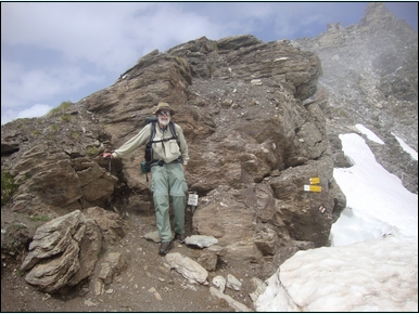
On June 19, 2012 I met my Adirondack Mountain Club group in Saas-Fee, and the following day began our eight-day tour; my photos of this tour will be available eventually. After our June 28 farewell breakfast, I began my solo Swiss adventure by moving to a Zermatt campground for one day, then starting (in reverse) on the “Chamonix-Zermatt Haute Route” by heading north on the Europaweg path to Grachen. I had 20 days, and Kev Reynolds’s guidebook shows a 15-day trip, but I quickly discovered that I couldn’t match his pace: His 6-hour days were 9½ for me, etc. — a 1.6 multiple worked pretty accurately. I could do a tough 11-hour day... but not two in a row. Rest days, primarly, led me to truncate the hike in Arolla. Still, it was a memorable hike, covering the Europaweg, Augstbord and Forcletta passes, and the high Cols du Sorebois and Tsate. I’m still frightened by the memory of being caught in a rockslide — how fortunate I was to escape with a bruised leg! Here’s a photo album of my solo Haute Route. There’s no slide-show feature; I suggest clicking on the first photo, selecting full-screen mode (F11 in Firefox), and clicking on the next photo when ready.
Scotland
In the summer of 2011, I flew to Glasgow for 7 weeks of hiking, leaving Baltimore-Washington International on May 26 and returning on July 14. Each of four albums covers about a fourth of my 48-day trip in about 40 photos. Captions appear when a photo is selected and the cursor is hovered over it. There’s no slide-show feature; I suggest clicking on the first photo, selecting full-screen mode (F11 in Firefox), and clicking on the next photo when ready. There’s also no “return to this page” option; my apologies, but you’ll have to rely on your browser. I use “Open Link in New Tab” and keep this page on its own tab.
I began with the 95-mile West Highland Way from Glasgow to Fort William, then the 75-mile Great Glen Way from Fort William to Inverness (it’s preceded by a few photos of my brief start on the Cape Wrath Trail, and followed by a few of a tourist-ship cruise on Loch Ness). I then took a bus to Aviemore and walked the 66-mile Speyside Way north to Buckie, and returned to Fort William for the obligatory climb of Ben Nevis, the UK’s highest mountain. My Scotland visit concluded with a bus back to Aviemore and eleven days in the Cairngorm Mountains.
Alaska
In the summer of 2010, I drove to Anchorage. The first of three albums about that trip, the 17-day drive north, is: North to Alaska.North to Alaska.The second album presents photos with captions of my 24 days in Alaska: John Alaska 2010. The third album, South from Alaska, tells a story of my 10-day drive from Anchorage to Maryland.
We flew to Anchorage on August 1, 2007, to visit our daughter Andrea, and returned to the lower 48 on August 13, 2007. Photographs in and around Anchorage ; of our trip to Kennicott , AK and the abandoned Kennicott Copper mine; of John’s Johnson Pass Trail hike August 9-10, 2007.
The Long Trail
In 2004, I hiked from Williamstown MA to Jonesville VT, about 185 miles, and in 2005 returned to Jonesville to complete the northern 85 miles. A photo album of the entire hike is: Long Trail. For those who would like more detail and don't mind reading, an illustrated story of the 2004 portion of the Long Trail hike is here (pdf, 11 pages). My 2005 pack, updated from that of 2004, was a Gregory Forester that weighed about 42 lbs. at the start, including 14 days of food. I always hike alone, and for about three complete days of hiking in the northern section (north of the Lamoille River) met no other hiker on the trail. The Green Mountain Club deserves huge thanks for maintaining this wonderful 270-mile trail.
Adirondacks
|
2015, Essex Chain Lakes: Enjoying the summer of 2015 at my Newcomb NY camp on Goodnow Flow, I decided to tackle the Essex Chain Lakes, recently opened to the public through a New York State land purchase. The parking area closest to the Chain’s principal access point, Deer Pond, is only 6.4 miles of lightly used dirt road from my camp. On August 17 I tried the old 12’ Phoenix Cascade in the Tacoma’s bed and found the center of gravity well inside. Slow and easy, in half an hour I was at the parking area. The photos tell the rest of the story. That day I covered 2nd to 5th Lakes, skipping the carry to 1st (and Grassy Pond) and the clogged channel to 6th.. A month later, September 16, I paddled directly to the carry from 2nd to 1st Lakes, explored First Lake, and then did the lightly used and rather difficult (even if fairly short) carry to Grassy Pond, where I arrived about noon. Solitude for sure! What a pleasant spot for lunch. The map shows a designated campsite here, but I don’t recall seeing it. After a thorough exploration of this small pond, we carried back to First, did the short carry to Second, and left the Lakes at the Third Lake take-out. Carrying back to Deer Pond and then (after paddling across it) to the parking area, we loaded up and headed for “home.” A pleasant day; nice to see Grassy! The photographic record of these two paddles is here. Captions appear when the cursor is hovered over the photo.
|
1995: My first backpacking hike. I’d discovered that a few hours of walking on a lightly traveled pleasant road would take me from our Newcomb camp to the Great Camp Santanoni portal to the High Peaks trail system. My hikes generally began about 9:00 AM, allowing a lunch stop at the picnic tables at the Camp Santanoni dairy house and a 4:00 to 4:30 PM conclusion of the first day’s walk at Moose Pond. In 1995 I did my first real backpacking trip.
1997: Avalanche Pass — my second backpacking trip. This year I ventured into the Eastern High Peaks, my first walk to them from our Newcomb camp.
1998: Four Corners — backpack #3. Another jaunt into the Eastern High Peaks; I’d never been to Four Corners, the saddle between Lake Colden (W) and Panther Gorge (E), and Skylight (S) and Marcy (N).
1999: Panther Gorge and my nine-day backpack #4. On this hike I passed through Four Corners to Panther Gorge, day-hiked Haystack and Marcy, and took the Adirondack Mountain Reserve trails to the Ausable Lakes. Returning to public land over the summit of Mount Colvin, I ended this hike at the Ausable Club parking lot on Route 73.
2000: The Northville-Placid Trail. A 39-photo album is available here. Since my college days I’d wanted to hike the 127-mile Northville-Placid Trail, and in July 2000 finally decided to do it. A friend rode with me to the Upper Benson trailhead and drove my truck back to our camp. Two weeks later, a couple of days after completing the Trail and visiting Lake Placid Village, I backtracked from Lake Placid to our Newcomb camp. Hover the cursor to see the captions.
In the summer of 2003, I attempted the trailless Dix Range in the Adirondacks... and wound up spending a night sleeping under the Northway (I-87) about 15 miles of road walking from my truck. It was quite an adventure, and it's chronicled here (pdf).
2004-5: The Long Trail
In January 2008, I hiked the trailless Seymour Mountain, in the Seward Range. I never made the summit, but did make several errors; live and learn, one hopes! Culminating in a 1:00 AM hitchhike into Saranac Lake, the story (with photos) is here (pdf).
|
2008, July 8-14: Lacking a few in the Western High Peaks for my “Adirondack 46” award, and always fascinated by the ability to walk from our cabin on the south side of Goodnow Flow into the High Peaks trail system, I began this 7-day hike on the morning of July 8 by walking away from our Goodnow cabin. As usual my first night was at Moose Pond and second at Northern Leanto #2 on the Cold River. At Duck Hole I usually turn right for the Eastern High Peaks, but today turned left. My third night plan, Ward Brook Leanto, arrived at only 11:30, so there was plenty of time to tackle Seymour after lunch. I headed up the Seymour herd path at 1:00, reaching the summit at 2:50 PM, and was back at Ward Brook by 5:30. Good day! Day 4 began with a 7:30 departure from Ward Brook Leanto. I located the herd-path cairn to Seward at 8:10 AM, and reached Seward’s summit at 11:00. After briefly considering a side trip to Emmons and Donaldson, I returned to the Seward summit and descended to the Ward Brook Leanto (12:30 to 4:45 PM). I spent my 4th night there, then backtracked “home,” with the 5th night at Northern #2, 6th at Moose Pond, and 7th at the Goodnow cabin. A great 7-day walk, picking up two “trailless” 46 peaks without driving anywhere. To pick up Emmons and Donaldson, on July 29 I drove to a Corey’s Road (off Rt 3, between Tupper and Saranac Lakes) parking area and found the Calkins Brook herd path, headed up from the west. I arrived at the Emmons summit at 11:15 AM and Donaldson’s at 1:10 PM. To descend, I took the path to the Seward summit (where I’d been two weeks earlier) and dropped down to the Ward Brook Truck Trail; a left (west) turn took me back to my vehicle. The photographic record of this hike is here. Captions appear when the cursor is hovered over the photo.
|
On Sunday January 11, 2010, I snowshoed Giant Mountain (#10 on the Adirondack 46 list) and then, the following Saturday (January 16), Rocky Peak Ridge (#21) (with a short side trip to the summit of Giant again). I picked up valuable experience at winter hiking, doing much better on the RPR/G hike than the previous Sunday. Here's a .pdf story about the January 11 hike, with some photos.
Amateur Radio
I have been an active amateur radio operator (“ham”) since the age of 14. I recently scanned some old photographs of my early years in this wonderful hobby, actually beginning with a shot before I had my Novice license and was “just” a short-wave listener. One of these days I’ll post some later photos. Except for the minimum operating that the FCC then required to hold one’s license, I was largely inactive from the early 1960s to the early 1980s.
Here’s the album of my early ham-radio photos. The captions appear when the cursor is hovered on the photo; a few have no captions.
Automobile adventures
In 1982 I drove my 1951 Hudson Pacemaker sedan from Towson MD to Essex Junction, Vermont, where I lived as a boy in the 1950s. After attending the Vermont Automobile Enthusiasts’ meet at the fairgrounds, I headed east through Smugglers’ Notch at Mount Mansfield and southeast to Exeter, NH, where I spoke with a young teacher at Phillips Exeter Academy who had first-hand experience with Ralph Borsodi’s commodity money, “the constant.” I left Exeter in mid-afternoon and drove straight through to Towson, arriving home about 2:00 AM. Click the Hudson_Vermont_1982 link for my photographs of this trip. (There is no slide show, but the caption appears when the cursor is hovered on a photo. Click on the first one, then choose full-screen (F11 in Firefox), and use the thumbnail image at the top to select the next photo.) The Hudson ran beautifully and I had a great time!
Commute
I was extremely fortunate to be able to walk to work. It was 4 miles, so I joked about my “hour-long commute,” but it was a delightful walk and — depending on how my classes went or whether I had committee meetings — was often a high point of my day. This is a short photographic record I took in 2005, after Spring classes had ended. My trek was usually from 6:00 AM to 7:15 AM: Johns_commute .
Summer 2023: For a photo album of this summer at the camp, click here.

 Lunch
on Grassy Pond
Lunch
on Grassy Pond Saranacs
from Seymour Summit
Saranacs
from Seymour Summit